Another chance of mixed precipitation Thursday night
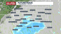
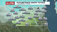
PLANNINGTHE NEXT24HOURS: We will be dealing with a rain/snow mix Wednesday afternoon. Winter weather advisories are to our north. Some minor wet snow accumulation is possible, but any accumulation will melt quickly. However, a few slick spots are still possible during the afternoon hours Wednesday.
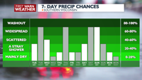
EXTENDEDFORECAST: Tere will be another quick system Thursday night, bringing in mostly rain, but some light snow could still mix in. High temperatures to end the work week will be in the 40s, but by the weekend and early next week, it could get even colder with highs in the 30s and possibly even 20s some days. There will also be a chance of snow over the weekend, and the First Warn Weather team is keeping an eye on the potential for snowfall accumulation from that system that could reach ALERT DAY levels.
COPYRIGHT 2026 BY CHANNEL 3000. ALL RIGHTS RESERVED. THIS MATERIAL MAY NOT BE PUBLISHED, BROADCAST, REWRITTEN OR REDISTRIBUTED.
Humidity: 96%
Feels Like: 24°
Heat Index: 31°
Wind: 8 mph
Wind Chill: 24°
UV Index: 1 Low
Sunrise:07:16:43 AM
Sunset:06:59:50 PM
Dew Point: 30°
Visibility: 1.5 mi
Today
Mostly cloudy, breezy, and much cooler with scattered rain and snow showers. Minor wet snow accumulation of an inch or less is possible.
Wind: N 10-20 MPH, gusts to 30 MPH
Tonight
Becoming mostly clear and colder.
Wind: N 5-10 MPH
Tomorrow
Becoming mostly cloudy and breezy with a slight chance for rain and snow showers late.
Wind: SW 8-15 MPH
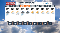
Wed Wednesday
38°/24°
Periods of snow early. Highs in the upper 30s and lows in the upper 20s.
Wednesday Night
Becoming mostly clear and colder.
Wind: N 5-10 MPH
Thu Thursday
46°/34°
Times of sun and clouds. Highs in the mid 40s and lows in the mid 30s.
Thursday Night
Breezy, with scattered rain and snow showers overnight. Some snow accumulation possible, mainly for areas north of The Dells.
Wind: SW 15-20 MPH, gusts to 35 MPH
Fri Friday
42°/26°
Windy with times of sun and clouds. Highs in the low 40s and lows in the mid 20s.
Friday Night
Mostly cloudy and a little cooler with a slight chance of flurries.
Sat Saturday
41°/30°
Mostly cloudy. Highs in the low 40s and lows in the low 30s.
Saturday Night
Breezy with a mix of rain and snow developing at night. Some snow accumulation is possible.
Sun Sunday
33°/10°
Watching a potential winter storm. Snow. Highs in the upper 30s and lows in the low teens.
Sunday Night
Mostly cloudy, breezy, and much colder with a chance of snow showers early.
Mon Monday
25°/8°
More clouds than sun. Highs in the low 20s and lows in the low single digits.
Monday Night
Partly cloudy and cold.
Tue Tuesday
30°/17°
A few clouds. Highs in the mid 20s and lows in the mid teens.
Tuesday Night
Mostly cloudy and cool with a slight chance for snow.
Wed Wednesday
38°/29°
Mostly cloudy. Highs in the upper 30s and lows in the mid 20s.
Wednesday Night
Mostly cloudy and cool with a slight chance of snow showers.
Thu Thursday
47°/33°
Considerable cloudiness. Highs in the low 50s and lows in the low 30s.
Thursday Night
Mostly cloudy with a slight chance of rain and snow showers.
Fri Friday
50°/35°
Considerable cloudiness. Highs in the upper 50s and lows in the mid 30s.
Friday Night
Low clouds and fog. Low around 35F. Winds NW at 5 to 10 mph.


