


HONOLULU (HawaiiNewsNow) – Your First Alert Weather Team has declared FIRST ALERT WEATHER DAYS through Saturday as a large and powerful Kona storm moves over the state. Here’s what to expect.
Current weather alerts
The following weather alerts are currently in effect:
Flood watch: Niihau, Kauai, Oahu, Maui County. A watch for Hawaii Island will go into effect Wednesday night.
High wind watch: Kauai County, Oahu, lower elevations of Maui County from Thursday evening through late Saturday night.
Learn more about current weather alerts here.
Hour-by-hour timeline
Here is the latest breakdown of the data from our First Alert Weather team. We will be monitoring this storm throughout the week so check back for updates.
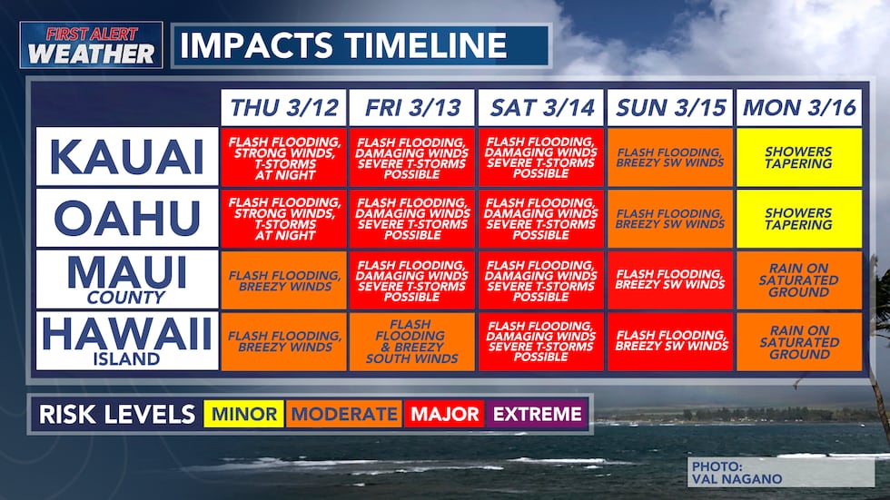
The latest data suggests that there will be two significant rounds of weather throughout this storm system. The first round occurred late Tuesday night and throughout early Wednesday morning.
The second, and potentially most impactful, part of this storm will occur Friday into the weekend. The second round is currently forecast to bring flash flooding, damaging south winds, and strong-to-severe thunderstorms.
This second round of storms is also currently forecast to drop more rainfall than the first. Some regions, especially those in the mountains, could easily receive above ten inches of rainfall.
Wednesday, March 11
Evening: Scattered downpours will continue throughout Wednesday evening. A combination of widespread instability and upper-level support could allow a few downpours to develop throughout the evening.
The flooding threat for Hawaii Island will increase throughout Wednesday, becoming more concerning throughout Thursday and Friday.
Night: Scattered pockets of rainfall will continue throughout the night. The risk for flash flooding will decrease slightly throughout Wednesday night.
Thursday, March 12
Morning: Downpours and flash flooding are still possible throughout Thursday, but will be relatively scattered.
Evening: Cloud cover and some lingering showers will be present across the entire state during the afternoon. There may be a slight window where the rain and storms calm down across the state in the early afternoon.
Widespread instability will still be in the atmosphere. Torrential rainfall and flash flooding are still possible throughout Thursday, but will be more scattered in nature.
The southerly winds will also weaken slightly, but could become strong in regions north of the mountains.
There is also the possibility of winter weather on the Big Island summits. Colder air wrapping into the storm system, combined with increasing moisture, could allow periods of heavy snowfall on the highest elevations later in the week and into the weekend, potentially leading to significant snow accumulation.
Night: The second, most impactful, round of weather from the Kona low will begin developing late Thursday night over the western half of the state. Thunderstorms, damaging south winds, and flash flooding will start to develop near Kauai. This band of storms will slowly start to march down the rest of the island chain into early Friday morning.
Friday, March 13
Morning: With the second round being more volatile, the already saturated grounds from the first round will be a big concern. Strong to severe thunderstorms, damaging south winds, and flash flooding are forecast to impact Kauai throughout Friday morning, potentially extending into Friday afternoon. Following the most impactful weather, winds will shift to be more southwesterly over Kauai.
Afternoon: The deep tropical moisture is forecast to impact Oahu starting around midday and extend through the afternoon. Strong to severe thunderstorms, damaging south winds, and flash flooding will impact Oahu.
Night: The thunderstorms over Oahu will extend into the late evening and through the night. This slow-moving band of thunderstorms could lead to large amounts of rainfall dropping without much time for drainage, increasing the threat of flash flooding. Potentially damaging south winds will continue.
Saturday, March 14
Morning: The deep plume of tropical moisture will march towards Molokai and Lanai early Saturday morning. The most impactful weather will reach Maui by early morning to midday on Saturday. Again, winds will shift to be more southwesterly behind the line of thunderstorms for Oahu and Kauai. Lingering showers will be present for the western half of the state.
Afternoon: Thunderstorms will be present over the eastern half of the state throughout Saturday afternoon. The initial band of thunderstorms could stall over eastern Maui Saturday afternoon and evening.
Pop-up and more scattered thunderstorms are expected for Hawaii Island. However, strong south winds are still expected throughout Saturday for Hawaii Island. Current models hint at higher rainfall totals for the Kona side of Hawaii Island.
Night: The stalled band could remain between Maui and Hawaii Island throughout the night, exacerbating the flooding risk.
Sunday, March 15
The flooding threat will start to decrease for Kauai and Oahu throughout Sunday. However, the ground will be so saturated that any additional rainfall could lead to quick runoff and flash flooding.
Flash flooding and breezy southwest winds are still expected for Maui County and Hawaii Island on Sunday, potentially extending into Monday for Hawaii Island.
Download the HNN Weather app from the Apple App Store or Google Play for the latest updates from your First Alert Weather Team: chief meteorologist Jennifer Robbins, meteorologist Drew Davis, and weather anchors Guy Hagi, Ben Gutierrez, and Billy V.

Copyright 2026 Hawaii News Now. All rights reserved.
